မိူင်းၾရၢင်ႇသဵတ်ႈ
(လုၵ်ႉတီး ၾရၢင်ႇသဵတ်ႈ ၼႆႈသေ ၶိုၼ်းပိၼ်ႇဝၢႆႇမႃး)
မိူင်းၸွမ်ပွင်ၸိုင်ႈ ၾရၢင်ႇသဵတ်ႈ République française (French) | |||||
|---|---|---|---|---|---|
| |||||
| ၶေႃႈၶၼ်ပၢၵ်ႇ: "Liberté, égalité, fraternité" ("Liberty, Equality, Fraternity") | |||||
| ၽဵင်းၸိူဝ်ႉၸၢတ်ႈ: "La Marseillaise" | |||||
Diplomatic emblem | |||||
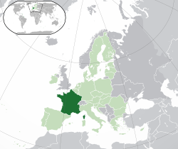
ဢွင်ႈတီႈ မိူင်းၾရၢင်ႇသဵတ်ႈ (blue or dark green) – ၼႂ်း လိုမ်ယူးရူပ်ႉ (green လႄႈ dark grey) | |||||
| ဝဵင်းလူင် and largest city | Paris 48°51′N 2°21′E / 48.850°N 2.350°E | ||||
| Official language and national language | French[upper-roman 2] | ||||
| Nationality (2021)[3] | |||||
| သႃႇသၼႃႇ (2021)[4] |
| ||||
| ၵူၼ်းၶိူဝ်းငဝ်ႈမိူင်း | French | ||||
| လူင်ပွင်ၸိုင်ႈ | Unitary semi-presidential republic | ||||
| Emmanuel Macron | |||||
| François Bayrou | |||||
| Gérard Larcher | |||||
| Yaël Braun-Pivet | |||||
| ၸုမ်းသၢင်ႈၵူတ်းမၢႆ | Parliament | ||||
| Senate | |||||
| National Assembly | |||||
| Establishment | |||||
| 10 August 843 | |||||
| 22 September 1792 | |||||
| 4 October 1958 | |||||
| လႅၼ်တီႈ | |||||
• ႁူမ်ႈလေႃး | 643,801 km2 (248,573 sq mi) (including metropolitan France and overseas France and excluding Terre Adelie[6]) (42nd) | ||||
• ၼမ်ႉ (%) | 0.86[5] | ||||
| 551,695 km2 (213,011 sq mi)[upper-roman 3] (50th) | |||||
• Metropolitan France (Cadastre) | 543,940.9 km2 (210,016.8 sq mi)[upper-roman 4][7] (50th) | ||||
| ႁူဝ်ၼပ်ႉၵူၼ်းမိူင်း | |||||
• January 2024 estimate | |||||
• Density | 106.20274/km2 (106th) | ||||
• Metropolitan France, estimate as of January 2024[update] | |||||
• Density | 122/km2 (316.0/sq mi) (89th) | ||||
| GDP (PPP) | 2024 estimate | ||||
• ႁူမ်ႈလေႃး | |||||
• Per capita | |||||
| GDP (nominal) | 2024 estimate | ||||
• ႁူမ်ႈလေႃး | |||||
• Per capita | |||||
| Gini (2022) | low inequality | ||||
| HDI (2022) | very high (28th) | ||||
| ယူင်ႉငိုၼ်းတွင်း |
| ||||
| ပွတ်းတွၼ်ႈၶၢဝ်းယၢမ်း | UTC+1 (CET[upper-roman 7]) | ||||
• ၶၢဝ်းမႆႈ (DST) | UTC+2 (CEST) | ||||
| ၶူတ်ႉႁွင်ႉၽူၼ်း | +33[upper-roman 8] | ||||
| ဢိၼ်ႇထႃႇၼႅတ်ႉ TLD | .fr[upper-roman 9] | ||||
Source gives area of metropolitan France as 551,500 km2 (212,900 sq mi) and lists overseas regions separately, whose areas sum to 89,179 km2 (34,432 sq mi). Adding these give the total shown here for the entire French Republic. The World Factbook reports the total as 643,801 km2 (248,573 sq mi). | |||||
မၢႆတွင်း
မႄးထတ်း- ↑ The current Constitution of France does not specify a national emblem.[1] The lictor's fasces is very often used to represent the French Republic, although it holds no official status.[2] In addition to the coat of arms, France also uses a different emblem for diplomatic and consular purposes.
- ↑ For information about regional languages, see Languages of France.
- ↑ French National Geographic Institute data, which includes bodies of water
- ↑ French Land Register data, which exclude lakes, ponds and glaciers larger than 1 km2 (0.386 sq mi or 247 acres) as well as the estuaries of rivers
- ↑ Whole of the except the overseas territories in the Pacific Ocean
- ↑ French overseas territories in the Pacific Ocean only
- ↑ Various other time zones are used in overseas France, from UTC−10 (French Polynesia) to UTC+12 (Wallis and Futana). For further information, view Time in France.
- ↑ The overseas regions and collectivities form part of the French telephone numbering plan, but have their own country calling codes: Guadeloupe +590; Martinique +596; French Guiana +594; Réunion and Mayotte +262; Saint Pierre and Miquelon +508. The overseas territories are not part of the French telephone numbering plan; their country calling codes are: New Caledonia +687; French Polynesia +689; Wallis and Futuna +681.
- ↑ In addition to .fr, several other Internet TLDs are used in French overseas départements and territories: .re, .mq, .gp, .tf, .nc, .pf, .wf, .pm, .gf and .yt. The .cat domain is used in Catalan-speaking territories, .eus in Basque-speaking territories and .bzh in Brittany.
ၽိုၼ်ဢိင်
မႄးထတ်း- ↑ Article II of the Constitution of France (1958)
- ↑ THE LICTOR'S FASCES (15 December 2022).
- ↑ L'essentiel sur... les immigrés et les étrangers.
- ↑ Etat des lieux de la laïcité en France - 2021 (in fr). Observatoire de la laïcité, Government of France.
- ↑ Surface water and surface water change. Organisation for Economic Co-operation and Development (OECD).
- ↑ Field Listing :: Area. IGN. This article incorporates text from this source, which is in the public domain.
- ↑ "France Métropolitaine" (2011). INSEE.
- ↑ Bilan démographique 2023 – Composantes de la croissance démographique, France (16 January 2023).
- ↑ Bilan démographique 2023 – Composantes de la croissance démographique, France métropolitaine (16 January 2024).
- ↑ 10.0 10.1 10.2 10.3 World Economic Outlook Database, October 2024 Edition. (France). International Monetary Fund (22 October 2024).
- ↑ Gini coefficient of equivalised disposable income – EU-SILC survey. Eurostat.
- ↑ Human Development Report 2023/24 (in en). United Nations Development Programme (13 March 2024).

![Coat of arms[upper-roman 1] of ၾရၢင်ႇသဵတ်ႈ](http://upload.wikimedia.org/wikipedia/commons/thumb/3/36/Arms_of_the_French_Republic.svg/75px-Arms_of_the_French_Republic.svg.png)


