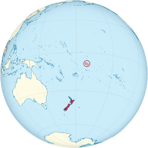
ထူဝ်းၵေႇလၢဝ်ႇ
(လုၵ်ႉတီး Tokelau ၼႆႈသေ ၶိုၼ်းပိၼ်ႇဝၢႆႇမႃး)
ထူဝ်းၵေႇလၢဝ်ႇ Tokelau | |||
|---|---|---|---|
Dependent territory ႁင်း ၼိဝ်းၸီႇလႅၼ်ႇ | |||
| |||
| ၶေႃႈၶၼ်ပၢၵ်ႇ | |||
| Territorial anthem: "Te Atua o Tokelau"[1] | |||
 | |||
 Map of all Tokelau Islands. Swains Island is shown to the south. | |||
| Sovereign state | ၼိဝ်းၸီႇလႅၼ်ႇ | ||
| Protectorate created | June 1889 | ||
| British colony | 29 February 1916 | ||
| Assigned to New Zealand | 11 February 1926 | ||
| New Zealand sovereignty | 1 January 1949 | ||
| ဝဵင်းငဝ်ႈၸိုင်ႈ | None[မၢႆတွင်း 1] | ||
| Largest city | Atafu | ||
| ၽႃႇသႃႇၸႂ်ႉၼႂ်းလုမ်း | |||
| ၵူၼ်းၸႃႇတိ | Tokelauan | ||
| လူင်ပွင်ၸိုင်ႈ | Devolved parliamentary dependency under a constitutional monarchy | ||
• ၼၢင်းႁေႃၶမ်း | Elizabeth II | ||
• Administrator | Ross Ardern | ||
| Kerisiano Kalolo | |||
| လုမ်းတႅၼ်းၽွင်း | General Fono | ||
| ဢေႇရိယႃႇ | |||
• ႁူမ်ႈ | 10 km2 (3.9 sq mi) | ||
• ၼမ်ႉ (%) | negligible | ||
| ၼႃႈလိၼ်သုင်သုတ်း | 5 မီႇတႃႇ (16 ထတ်း) | ||
| ႁူဝ်ၼပ်ႉၵူၼ်း | |||
• သဵၼ်ႈမၢႆႁူဝ်ႁိူၼ်း 2016 | 1,499[3] (237th) | ||
• လွင်ႈသတ်ႉ | 115/km2 (297.8/sq mi) (86th) | ||
| GDP (PPP) | 2017 estimate | ||
• ႁူမ်ႈ | US$10 million[4] | ||
ငိုၼ်းၶဝ်ႈ ၼိုင်ႈၵေႃႉ | US$6,275 (not ranked) | ||
| ငိုၼ်း | New Zealand dollar (NZ$) (NZD) | ||
| ၶၢဝ်းယၢမ်းၼႃႈလိၼ် | UTC+13:00 | ||
| ပိူင်ဝၼ်းတီႈ | dd/mm/yyyy | ||
| ပိူင်သၢႆလူတ်ႉ | မိုဝ်းသၢႆႉ | ||
| ၶူတ်ႉတႄႇလီႇၾူင်း | +690 | ||
| ၶူတ်ႉ ISO 3166 | TK | ||
| TLD ဢိၼ်ႇထႃႇၼႅတ်ႉ | .tk | ||
မၢႆတွင်း
မႄးထတ်း- ↑ Each atoll has its own administrative centre.
ၽိုၼ်ဢိင်
မႄးထတ်း- ↑ Government of Tokelau (in en). Retrieved on 20 September 2017။
- ↑ Tokelau Info. Tokelau-info.tk. Archived from the original on 26 October 2013။ Retrieved on 30 December 2011။
- ↑ Final population counts: 2016 Tokelau Census. Statistics New Zealand. November 2016. p. 3.
- ↑ Tokelau’s Gross Domestic Product determined for first time this century.

