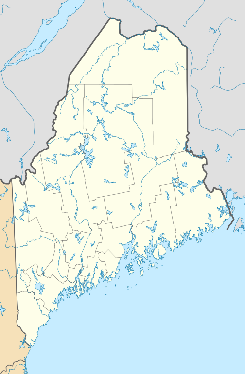
ၾၢႆႇ:USA Maine location map.svg

Size of this PNG preview of this SVG file: 393 × 599 ၽိၵ်ႉသႄႇလ်. resolutionsတၢင်ႇဢၼ် : 157 × 240 ၽိၵ်ႉသႄႇလ် | 315 × 480 ၽိၵ်ႉသႄႇလ် | 504 × 768 ၽိၵ်ႉသႄႇလ် | 672 × 1,024 ၽိၵ်ႉသႄႇလ် | 1,343 × 2,048 ၽိၵ်ႉသႄႇလ် | 820 × 1,250 ၽိၵ်ႉသႄႇလ် ။
ၾၢႆႇငဝ်ႈတိုၼ်း (ၾၢႆႇ SVG, ၸိုဝ်ႈ 820 × 1,250 pixels, သႅၼ်းၾၢႆႇ : 606 KB)
ႁူဝ်ႁုပ်ႈ
| ၶေႃႈသပ်းလႅင်း |
Quadratische Plattkarte, N-S-Streckung 140.0 %. Geographische Begrenzung der Karte:
Equirectangular projection, N/S stretching 140.0 %. Geographic limits of the map:
|
| ဝၼ်းထီႉ | |
| ငိူၼ်ႈငဝ်ႈတိုၼ်း | ၵၢၼ်ၶွင်တူဝ် |
| ၽူႈတႅမ်ႈလိၵ်ႈ | Alexrk2 |
| Other versions |
Derivative works of this file: |

|
This map has been made or improved in the German Kartenwerkstatt (Map Lab). You can propose maps to improve as well.
|
ဝ်ႂ
I, the copyright holder of this work, hereby publish it under the following licenses:

|
ပၼ်ၶႂၢင်ႉ တႃႇတေ ထုတ်ႇဢဝ်၊ ၽႄႈတိုၼ်း လႄႈ/ဢမ်ႇၼၼ် မႄးထတ်း ၼႂ်းလိၵ်ႈၼႆႉ ၸွမ်းၼင်ႇ ၶေႃႈမၼ်ႈၸႂ် GNU Free Documentation License, Version 1.2 ဢမ်ႇၼၼ် ၸိူဝ်းပဵၼ် မၢႆဢွၵ်ႇ ဢၼ်ထုၵ်ႇပိုၼ်ဢွၵ်ႇ ဝၢႆးလင် ၼင်ႇ Free Software Foundation; ဢၼ်ဢမ်ႇမီး လွင်ႈလႅၵ်ႈလၢႆႈ ၵႃႈတီႈ တွၼ်ႈၵၼ်၊ လိၵ်ႈၸိူဝ်းမီးတီႈ ၼႃႈသိုဝ်ႈၽၢႆႈၼႃႈ၊ ၼႃႈသိုဝ်ႈၽၢႆႇလင်။ဢၼ်ပဵၼ် ဝႂ်တႃႇထုတ်ႇဢဝ်ၼႆႉ မၼ်းတေၶဝ်ႈပႃးဝႆႉ ၵႃႈတီႈ တွၼ်ႈၵၼ် ဢၼ်မီးႁူဝ်ၶေႃႈဝႃႈ GNU Free Documentation License ၼၼ်ႉ။ |
This file is licensed under the Creative Commons Attribution 3.0 Unported license.
- ၸဝ်ႈၵဝ်ႇထၢင်ႇႁၢင်ႈ
- တႃႇၽႄၸႂ်ႉ – တွၼ်ႈတႃႇထုတ်ႇဢဝ်၊ ပိုၼ်ၽႄႈ လႄႈ ပိုၼ်ဢွၵ်ႇပၼ် ၼႃႈၵၢၼ်။
- ၶိုၼ်းထႅမ်သႂ်ႇ – မႄးထွင်ၵၢၼ် ႁႂ်ႈသၢင်ႇထုၵ်ႇ
- ၸွမ်းၼင်ႇ သၢႆႇငၢႆတီႈတႂ်ႈၼႆႉ
- ႁၢင်ႈၽၢင်ၶဝ်ႈပႃး – ၸဝ်ႈၵဝ်ႇတေလႆႈမွၵ်ႇပၼ်ၸိုဝ်ႈ ဢၼ်သၢင်ႇထုၵ်ႇ တွၼ်ႈတႃႇ ႁဵင်းၵွင်ႉ ဢၼ်ၵမ်ႉထႅမ်ပၼ် ဝႂ်ၶႂၢင်း လႄႈ သင်ၸိူဝ်ႉဝႃႈ လႆႈမီးလွင်ႈလႅၵ်ႈလၢႆႈမႃးၼႆ ၶႅၼ်းတေႃႈ ၸီႉၼႄပၼ်သေၵမ်း။ ၸဝ်ႈၵဝ်ထုၵ်ႇလီႁဵတ်း ႁႂ်ႈပဵၼ်တၢင်းႁဵတ်းသၢင်ႈ မီးလွင်ႈမီးတၢင်းမၼ်း၊ ၵူၺ်းၵႃႈဝႃႈ မၼ်းဢမ်ႇမၢႆထိုင်ဝႃႈ ဝႂ်ၶႂၢင်းၼၼ်ႉ မၼ်းတေပဵၼ် ဢၼ်ၸွႆႈဢၼ်ၵမ်ႉထႅမ်ပၼ် ၸဝ်ႈၵဝ်ႇ ဢမ်ႇၼၼ် ဢၼ်ၸဝ်ႈၵဝ်ႇၸႂ်ႉဝႆႉၼၼ်ႉ။
ၸဝ်ႈၵဝ်ႇထုၵ်ႇလိူၵ်ႈ ဝႆတွၼ်ႈတႃႇ ဢၼ်ၸဝ်ႈၵဝ်ႇလိူၵ်ႈၼၼ်ႉ
ပိုၼ်းၾၢႆႇ
တဵၵ်းၼိူဝ် ဝၼ်းထိ/ၶၢဝ်းယၢမ်း တႃႇႁၼ်ၾၢႆႇ ၼႂ်းဝၼ်းၼၼ်ႉ
| ဝၼ်းထီႉ/ၶၢဝ်းယၢမ်း | ႁၢင်ႈလဵၵ်ႉ | သႅၼ်းမၼ်း | ၽူႈၸႂ်ႉတိုဝ်း | တၢင်းႁၼ်ထိုင် | |
|---|---|---|---|---|---|
| ယၢမ်းလဵဝ် | 15:53, 26 ၸုၼ်ႇ 2009 | | 820 × 1,250 (606 KB) | Alexrk2 | == Beschreibung == {{Information |Description= {{de|Positionskarte von Maine, USA}} Quadratische Plattkarte, N-S-Streckung 140.0 %. Geographische Begrenzung der Karte: * N: 47.7° N * S: 42.7° N * W: 71.3° W * O: 66.7° W {{en| |
လွင်ႈၸႂ်ႉတိုဝ်း ၾၢႆႇ
4 ၼႃႈလိၵ်ႈ ၵွင်ႉမႃးၸူးၾၢႆႇၼႆႉ:
လွင်ႈၸႂ်ႉတိုဝ်းၾၢႆႇလူမ်ႈၽႃႉ
Wikis ၸိူဝ်းဢၼ်ၸႂ်ႉဝႆႉ ၾၢႆႇဢၼ်ၼႆႉ:
- ၸႂ်ႉဝႆႉ an.wikipedia.org
- ၸႂ်ႉဝႆႉ ar.wikipedia.org
- ၸႂ်ႉဝႆႉ azb.wikipedia.org
- هرمون، مین
- مکزیکو ، مین
- بار هاربر ، مین
- سنت دیوید، مین
- موسلوکمقانتیک، مین
- استرانق، مین
- میپلتون ، مین
- گونئی جنوبغربی هاربر ، مین
- کستین ، مین
- باکسپورت ، مین
- داماریسکوتا-نیوکسل، مین
- بتل، مین
- همپدن ، مین
- فورست سیتی، مین
- جوناسپورت، مین
- پیتسفیلد ، مین
- کراتونک، مین
- مارس هیل ، مین
- وینتر هاربر ، مین
- هاولند ، مین
- دکستر ، مین
- مسکو، مین
- ویلتون ، مین
- نیوپورت ، مین
- مارس هیل-بلین، مین
- بلو هیل ، مین
- واشبرن ، مین
- اشلند ، مین
- اورورا، مین
- فارمینقتون ، مین
- هولتون، میزوری
- بینقام، مین
- اسکوهیقان، مین
- آکتون، مئین
- آدیسون، مئین
- وایت، مئین
- الکساندر، مئین
- تالمادج، مئین
- آلفرد، مئین
- کراوفورد، مئین
- والاقراس، مئین
- والتام، مئین
- نیوپورت، مئین
- تمپل، مئین
- آلتون، مئین
တူၺ်း ၾၢႆႇmore global usage ဢၼ်ၼႆႉ