ၾၢႆႇ:Myanmar location map.svg

Size of this PNG preview of this SVG file: 285 × 599 ၽိၵ်ႉသႄႇလ်. resolutionsတၢင်ႇဢၼ် : 114 × 240 ၽိၵ်ႉသႄႇလ် | 228 × 480 ၽိၵ်ႉသႄႇလ် | 365 × 768 ၽိၵ်ႉသႄႇလ် | 487 × 1,024 ၽိၵ်ႉသႄႇလ် | 975 × 2,048 ၽိၵ်ႉသႄႇလ် | 1,200 × 2,520 ၽိၵ်ႉသႄႇလ် ။
ၾၢႆႇငဝ်ႈတိုၼ်း (ၾၢႆႇ SVG, ၸိုဝ်ႈ 1,200 × 2,520 pixels, သႅၼ်းၾၢႆႇ : 633 KB)
ႁူဝ်ႁုပ်ႈ
| ၶေႃႈသပ်းလႅင်း |
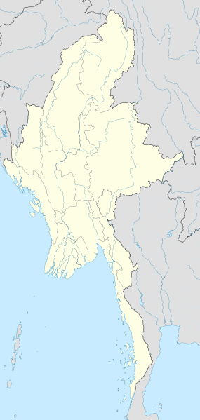
English: Location map of Myanmar. Equirectangular projection. Strechted by 105.0%. Geographic limits of the map: * N: 29.0° N * S: 9.0° N * W: 92.0° E * E: 102.0° E Made with Natural Earth. Free vector and raster map data @ naturalearthdata.com. |
| ဝၼ်းထီႉ | |
| ငိူၼ်ႈငဝ်ႈတိုၼ်း | ၵၢၼ်ၶွင်တူဝ် |
| ၽူႈတႅမ်ႈလိၵ်ႈ | Uwe Dedering |
ဝ်ႂ
I, the copyright holder of this work, hereby publish it under the following licenses:
ၾၢႆႇဢၼ်ၼႆႉၼႆႉ မီးသုၼ်ႇဝႂ် ပႃႈတႂ်ႈ ၶွင် Creative Commons Attribution-Share Alike 3.0 Unported ဝႆႉၼႆႉ။
- ၸဝ်ႈၵဝ်ႇထၢင်ႇႁၢင်ႈ
- တႃႇၽႄၸႂ်ႉ – တွၼ်ႈတႃႇထုတ်ႇဢဝ်၊ ပိုၼ်ၽႄႈ လႄႈ ပိုၼ်ဢွၵ်ႇပၼ် ၼႃႈၵၢၼ်။
- ၶိုၼ်းထႅမ်သႂ်ႇ – မႄးထွင်ၵၢၼ် ႁႂ်ႈသၢင်ႇထုၵ်ႇ
- ၸွမ်းၼင်ႇ သၢႆႇငၢႆတီႈတႂ်ႈၼႆႉ
- ႁၢင်ႈၽၢင်ၶဝ်ႈပႃး – ၸဝ်ႈၵဝ်ႇတေလႆႈမွၵ်ႇပၼ်ၸိုဝ်ႈ ဢၼ်သၢင်ႇထုၵ်ႇ တွၼ်ႈတႃႇ ႁဵင်းၵွင်ႉ ဢၼ်ၵမ်ႉထႅမ်ပၼ် ဝႂ်ၶႂၢင်း လႄႈ သင်ၸိူဝ်ႉဝႃႈ လႆႈမီးလွင်ႈလႅၵ်ႈလၢႆႈမႃးၼႆ ၶႅၼ်းတေႃႈ ၸီႉၼႄပၼ်သေၵမ်း။ ၸဝ်ႈၵဝ်ထုၵ်ႇလီႁဵတ်း ႁႂ်ႈပဵၼ်တၢင်းႁဵတ်းသၢင်ႈ မီးလွင်ႈမီးတၢင်းမၼ်း၊ ၵူၺ်းၵႃႈဝႃႈ မၼ်းဢမ်ႇမၢႆထိုင်ဝႃႈ ဝႂ်ၶႂၢင်းၼၼ်ႉ မၼ်းတေပဵၼ် ဢၼ်ၸွႆႈဢၼ်ၵမ်ႉထႅမ်ပၼ် ၸဝ်ႈၵဝ်ႇ ဢမ်ႇၼၼ် ဢၼ်ၸဝ်ႈၵဝ်ႇၸႂ်ႉဝႆႉၼၼ်ႉ။
- သျေး ဢၼ်မိူၼ် – သင်ၸိူဝ်ႉဝႃႈ ၸဝ်ႈၵဝ်ႇ ၶိုၼ်းလေႃး၊ လႅၵ်ႈလၢႆႈ၊ မႄးၶိုၼ်း ဢမ်ႇၼၼ် ၵေႃႇသၢင်ႈ ၵႃႈတီႈၼိူဝ် ၼႃႈၵၢၼ်ၼႆႉၸိုင်၊ ၸဝ်ႈၵဝ်ႇ တေလႆႈဢဝ် လွင်ႈၸွႆႈသၢင်ႈၸဝ်ႈၵဝ်ႇၼႆႉ ပိုၼ်ၽႄႈ ၽၢႆႇတႂ်ႈ မိူၼ်ၼင်ႇ ဢမ်ႇၼၼ် ဝႂ်ငမ်ႇမႅၼ်ႈ ၼင်ႇ ငဝ်ႈတိုၼ်းမၼ်းၼၼ်ႉယဝ်ႉ။

|
ပၼ်ၶႂၢင်ႉ တႃႇတေ ထုတ်ႇဢဝ်၊ ၽႄႈတိုၼ်း လႄႈ/ဢမ်ႇၼၼ် မႄးထတ်း ၼႂ်းလိၵ်ႈၼႆႉ ၸွမ်းၼင်ႇ ၶေႃႈမၼ်ႈၸႂ် GNU Free Documentation License, Version 1.2 ဢမ်ႇၼၼ် ၸိူဝ်းပဵၼ် မၢႆဢွၵ်ႇ ဢၼ်ထုၵ်ႇပိုၼ်ဢွၵ်ႇ ဝၢႆးလင် ၼင်ႇ Free Software Foundation; ဢၼ်ဢမ်ႇမီး လွင်ႈလႅၵ်ႈလၢႆႈ ၵႃႈတီႈ တွၼ်ႈၵၼ်၊ လိၵ်ႈၸိူဝ်းမီးတီႈ ၼႃႈသိုဝ်ႈၽၢႆႈၼႃႈ၊ ၼႃႈသိုဝ်ႈၽၢႆႇလင်။ဢၼ်ပဵၼ် ဝႂ်တႃႇထုတ်ႇဢဝ်ၼႆႉ မၼ်းတေၶဝ်ႈပႃးဝႆႉ ၵႃႈတီႈ တွၼ်ႈၵၼ် ဢၼ်မီးႁူဝ်ၶေႃႈဝႃႈ GNU Free Documentation License ၼၼ်ႉ။ |
ၸဝ်ႈၵဝ်ႇထုၵ်ႇလိူၵ်ႈ ဝႆတွၼ်ႈတႃႇ ဢၼ်ၸဝ်ႈၵဝ်ႇလိူၵ်ႈၼၼ်ႉ
| Annotations | This image is annotated: View the annotations at Commons |
ပိုၼ်းၾၢႆႇ
တဵၵ်းၼိူဝ် ဝၼ်းထိ/ၶၢဝ်းယၢမ်း တႃႇႁၼ်ၾၢႆႇ ၼႂ်းဝၼ်းၼၼ်ႉ
| ဝၼ်းထီႉ/ၶၢဝ်းယၢမ်း | ႁၢင်ႈလဵၵ်ႉ | သႅၼ်းမၼ်း | ၽူႈၸႂ်ႉတိုဝ်း | တၢင်းႁၼ်ထိုင် | |
|---|---|---|---|---|---|
| ယၢမ်းလဵဝ် | 16:08, 29 သႅပ်ႇထႅမ်ႇပႃႇ 2011 | | 1,200 × 2,520 (633 KB) | NordNordWest | corr, see disk |
| 17:45, 18 ၾႅပ်ႇဝႃႇရီႇ 2010 |  | 1,200 × 2,520 (968 KB) | Uwe Dedering | no disputed countries | |
| 13:03, 18 ၾႅပ်ႇဝႃႇရီႇ 2010 |  | 1,200 × 2,520 (974 KB) | Uwe Dedering | {{Information |Description={{en|1=Location map of Myanmar. Equirectangular projection. Strechted by 105.0%. Geographic limits of the map: * N: 29.0° N * S: 9.0° N * W: 92.0° E * E: 102.0° E Made with Natural Earth. Free vector and raster map dat |
လွင်ႈၸႂ်ႉတိုဝ်း ၾၢႆႇ
ၼႃႈလိၵ်ႈ ၸိူဝ်းၵွင်ႉသၢၼ် ဝႆႉၸူးၾၢႆႇဢၼ်ၼႆႉ မၼ်းၼမ်မီးၼမ်လိူဝ်သေ 100 ဢၼ်ၶႃႈ။ သဵၼ်ႈမၢႆ ၸိူဝ်းဢၼ်ၼႄဝႆႉ ၽၢႆႇတႂ်ႈၼႆႉ ႁဵင်းၵွင်ႉၸိူဝ်းမီးတီႈ ၼႃႈလိၵ်ႈဢွၼ်တၢင်းသုတ်း တႃ ၾၢႆႇဢၼ်ၼႆႉၵူၺ်းၶႃႈ။ သဵၼ်ႈမၢႆတဵမ်ထူၼ်ႈ ၵေႃႈ ၸၢင်ႈဢဝ်တူၺ်းလႆႈယူႇၶႃႈ။
- ငတယွၵ်ႉ၊ ဝဵင်း
- ငၸုၼ်ႇ၊ ဝဵင်း
- ငၸုၼ်ႇ၊ ၸႄႈဝဵင်း
- တတ်းတႅပ်း၊ ဝၢၼ်ႈ
- တတ်ႉၵူင်း၊ ဝဵင်း
- တတ်ႉၵူင်း၊ ၸႄႈဝဵင်း
- တတႃးဢူး၊ ဝဵင်း
- တတႃးဢူး၊ ၸႄႈဝဵင်း
- တပဵၵ်ႉၵျိၼ်း၊ ဝဵင်း
- တပဵၵ်ႉၵျိၼ်း၊ ၸႄႈဝဵင်း
- တလ၊ ၸႄႈဝဵင်း
- တိင်ႇၵၢၼ်းၵျုၼ်း၊ ၸႄႈဝဵင်း
- တိုင်းၵႂၢင်ႉ၊ ဝၢၼ်ႈ
- တိုဝ်ႉလူင်၊ ဝၢၼ်ႈ
- တိုဝ်ႉၼိဝ်ႉ၊ ဝၢၼ်ႈ
- တိုဝ်ႉႁႃႇယိူင်း၊ ဝၢၼ်ႈ
- တီးမေႃႉသူဝ်ႇ၊ ၸႄႈဝဵင်း
- တုၼ်ႇတေး၊ ဝဵင်း
- တုၼ်ႇတေး၊ ၸႄႈဝဵင်း
- တူင်းၶႂႃႉ၊ ဝဵင်း
- တူင်းၶႂႃႉ၊ ၸႄႈဝဵင်း
- တူင်ႈတႃႈ၊ ဝဵင်း
- တူၼ်ႈတီး
- တူၼ်ႈတီး၊ ၸႄႈတွၼ်ႈ
- တူၼ်ႈတီး၊ ၸႄႈဝဵင်း
- တေႃးပူင်ႇ၊ ၸႄႈဝဵင်း
- တဵင်း၊ ဝၢၼ်ႈ
- တွင်ႇငူႇ၊ ဝဵင်း
- တွင်ႇငူႇ၊ ၸႄႈတွၼ်ႈ
- တွင်ႇငူႇ၊ ၸႄႈဝဵင်း
- တွင်ႇတႂိၼ်းၵျီး၊ ဝဵင်း
- တွင်ႇတႂိၼ်းၵျီး၊ ၸႄႈဝဵင်း
- တွင်ႇတႃႇ၊ ဝဵင်း
- တွင်ႇတႃႇ၊ ၸႄႈဝဵင်း
- တွင်ႇဢူၵ်ႉၵလႃႇပ၊ ၸႄႈဝဵင်း
- တၢင်ႉယၢၼ်း၊ ဝဵင်း
- တၢင်ႉယၢၼ်း၊ ၸႄႈဝဵင်း
- တၢၼ်ႇလိၼ်ႇ၊ ဝဵင်း
- တၢၼ်ႇလိၼ်ႇ၊ ၸႄႈဝဵင်း
- တၵူင်ႇမျူဝ်ႉတိတ်ႉပွတ်းဢွၵ်ႇ၊ ၸႄႈဝဵင်း
- တၵူင်ႇမျူဝ်ႉတိတ်ႉပွတ်းၸၢၼ်း၊ ၸႄႈဝဵင်း
- တၵူင်ႇမျူဝ်ႉတိတ်ႉပွတ်းႁွင်ႇ၊ ၸႄႈဝဵင်း
- တၵူင်ႇမျူဝ်ႉတိတ်ႉသဵၵ်ႉၵၢၼ်း၊ ၸႄႈဝဵင်း
- တၵူင်ႇ၊ ၸႄႈဝဵင်း
- တၼၢတ်ႉပိၼ်ႇ၊ ဝဵင်း
- တၼၢတ်ႉပိၼ်ႇ၊ ၸႄႈဝဵင်း
- တႃႇမူၺ်ႇ၊ ၸႄႈဝဵင်း
- တႃႇၵေႇတ၊ ၸႄႈဝဵင်း
- တႃႇၸီႇ၊ ဝဵင်း
- တႃႇၸီႇ၊ ၸႄႈဝဵင်း
- တႃႈတိုင်းၶမ်း၊ ဝၢၼ်ႈ
- တႃႈလိူဝ်ႇ (မိူင်းတႆး)၊ ဝဵင်း
- တႃႈလိူဝ်ႇ၊ ဝဵင်း
- တႃႈလိူဝ်ႇ၊ ၸႄႈတွၼ်ႈ
- တႃႈ၊ ဝၢၼ်ႈ
- တႃႈၵုင်ႈ၊ ဝဵင်း
- တႃႈၵွင်၊ ဝဵင်း
- တႃႈၶီႈလဵၵ်း၊ ဝဵင်း
- တႃႈၶီႈလဵၵ်း၊ ၸႄႈတွၼ်ႈ
- တႃႈၶီႈလဵၵ်း၊ ၸႄႈဝဵင်း
- တႅၵ်ႉဢူး၊ ဝဵင်း
- တႅၵ်ႉဢူး၊ ၸႄႈဝဵင်း
- တႅၵ်ႉၵျီး၊ ဝဵင်း
- တႅၵ်ႉၵျီး၊ ၸႄႈဝဵင်း
- တႅၼ်ႈပုတ်း၊ ဝၢၼ်ႈ
- ထၢၼ်းတပိၼ်ႇ၊ ဝဵင်း (ၸႄႈတိူင်းတႃႈၵုင်ႈ)
- ထၢၼ်းတပိၼ်ႇ၊ ၸႄႈဝဵင်း (ၸႄႈတိူင်းတႃႈၵုင်ႈ)
- ပတဵင်ႇ၊ ဝဵင်း
- ပတဵင်ႇၵျီး၊ ဝဵင်း
- ပတဵင်ႇၵျီး၊ ၸႄႈဝဵင်း
- ပပႄးတၢၼ်း၊ ၸႄႈဝဵင်း
- ပုင်းထုၼ် (လၢင်းၶိူဝ်း)၊ ဝၢၼ်ႈ
- ပုင်းထုၼ် (ဢိူင်ႇဝၢၼ်ႈၸိတ်ႇ)
- ပုင်ႇပႃႇၶႅမ်၊ ဝဵင်း
- ပူင်း၊ ဝၢၼ်ႈ (သူၼ်ပူင်း)
- ပူဝ်ႇတထွင်ႇ၊ ၸႄႈဝဵင်း
- ပူးၵမ်ႇ၊ ဝဵင်း
- ပူးၵမ်ႇ၊ ဝၢၼ်ႈ
- ပျီႇၵျီးတၶုၼ်ႇ၊ ၸႄႈဝဵင်း
- ပျုၼ်ႇတၢၼ်ႇသႃႇ၊ ဝဵင်း
- ပျေႃႇပွႆႇ၊ ဝဵင်း
- ပျေႃႇပွႆႇ၊ ၸႄႈဝဵင်း
- ပၢင်ပဝ်း၊ ဝၢၼ်ႈ
- ပၢင်မၢၵ်ႇၼႃႉ၊ ဝဵင်း
- ပၢင်မၢၵ်ႇၼႃႉ၊ ၸႄႈဝဵင်း
- ပၢင်ယၢင်း၊ ဝဵင်း
- ပၢင်လူင် (ဢိူင်ႇမႆႉဢုၼ်လဝ်း)၊ ဝၢၼ်ႈ
- ပၢင်လူင်၊ ဝဵင်း
- ပၢင်လွင်း၊ ဝဵင်း
- ပၢင်လွင်း၊ ၸႄႈဝဵင်း
- ပၢင်ဝၢႆ၊ ဝဵင်း
- ပၢင်ဝၢႆ၊ ၸႄႈဝဵင်း
- ပၢင်သၢင်း၊ ဝဵင်း
- ပၢင်သၢင်း၊ ၸႄႈဝဵင်း
- ပၢင်းတရႃႉ၊ ဝဵင်း
- ပၢင်းတရႃႉ၊ ၸႄႈဝဵင်း
- ပၢင်ၵႅၼ်ႇ၊ ဝၢၼ်ႈ
- ပၢင်ၶမ်ႉ၊ ဝဵင်း
- ပၢင်ၸၢင်ႉ၊ ဝၢၼ်ႈ
- ပၢင်ႇတဝိ၊ ဝၢၼ်ႈ
တူၺ်း ႁဵင်းၵွင်ႉတၢင်ႇၸိူဝ်း ၸူး ၾၢႆႇဢၼ်ၼႆႉ။
လွင်ႈၸႂ်ႉတိုဝ်းၾၢႆႇလူမ်ႈၽႃႉ
Wikis ၸိူဝ်းဢၼ်ၸႂ်ႉဝႆႉ ၾၢႆႇဢၼ်ၼႆႉ:
- ၸႂ်ႉဝႆႉ af.wikipedia.org
- ၸႂ်ႉဝႆႉ an.wikipedia.org
- ၸႂ်ႉဝႆႉ ar.wikipedia.org
- ၸႂ်ႉဝႆႉ az.wikipedia.org
- ၸႂ်ႉဝႆႉ ba.wikipedia.org
- ၸႂ်ႉဝႆႉ be.wikipedia.org
- ၸႂ်ႉဝႆႉ bg.wikipedia.org
- ၸႂ်ႉဝႆႉ bh.wikipedia.org
- ၸႂ်ႉဝႆႉ bn.wikipedia.org
တူၺ်း ၾၢႆႇmore global usage ဢၼ်ၼႆႉ