ၾၢႆႇ:Kosovo location map.svg

Size of this PNG preview of this SVG file: 529 × 599 ၽိၵ်ႉသႄႇလ်. resolutionsတၢင်ႇဢၼ် : 212 × 240 ၽိၵ်ႉသႄႇလ် | 424 × 480 ၽိၵ်ႉသႄႇလ် | 678 × 768 ၽိၵ်ႉသႄႇလ် | 904 × 1,024 ၽိၵ်ႉသႄႇလ် | 1,808 × 2,048 ၽိၵ်ႉသႄႇလ် | 1,015 × 1,150 ၽိၵ်ႉသႄႇလ် ။
ၾၢႆႇငဝ်ႈတိုၼ်း (ၾၢႆႇ SVG, ၸိုဝ်ႈ 1,015 × 1,150 pixels, သႅၼ်းၾၢႆႇ : 149 KB)

|
The boundaries on this map show the de facto situation. This is just one of several different views on the subject (see COM:NPOV). |
ၵႂၢမ်းယေႃး
| ၶေႃႈသပ်းလႅင်း |
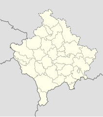
Deutsch: Positionskarte des Kosovo
Quadratische Plattkarte, N-S-Streckung 140 %. Geographische Begrenzung der Karte:
English: Location map of Kosovo
Equirectangular projection, N/S stretching 140 %. Geographic limits of the map:
|
| ဝၼ်းထီႉ | 01-08-2008 |
| ငိူၼ်ႈငဝ်ႈတိုၼ်း | own work, using United States National Imagery and Mapping Agency data |
| ၽူႈတႅမ်ႈလိၵ်ႈ | NordNordWest |

|
This map has been made or improved in the German Kartenwerkstatt (Map Lab). You can propose maps to improve as well.
|
ဝ်ႂ
I, the copyright holder of this work, hereby publish it under the following licenses:

|
ပၼ်ၶႂၢင်ႉ တႃႇတေ ထုတ်ႇဢဝ်၊ ၽႄႈတိုၼ်း လႄႈ/ဢမ်ႇၼၼ် မႄးထတ်း ၼႂ်းလိၵ်ႈၼႆႉ ၸွမ်းၼင်ႇ ၶေႃႈမၼ်ႈၸႂ် GNU Free Documentation License, Version 1.2 ဢမ်ႇၼၼ် ၸိူဝ်းပဵၼ် မၢႆဢွၵ်ႇ ဢၼ်ထုၵ်ႇပိုၼ်ဢွၵ်ႇ ဝၢႆးလင် ၼင်ႇ Free Software Foundation; ဢၼ်ဢမ်ႇမီး လွင်ႈလႅၵ်ႈလၢႆႈ ၵႃႈတီႈ တွၼ်ႈၵၼ်၊ လိၵ်ႈၸိူဝ်းမီးတီႈ ၼႃႈသိုဝ်ႈၽၢႆႈၼႃႈ၊ ၼႃႈသိုဝ်ႈၽၢႆႇလင်။ဢၼ်ပဵၼ် ဝႂ်တႃႇထုတ်ႇဢဝ်ၼႆႉ မၼ်းတေၶဝ်ႈပႃးဝႆႉ ၵႃႈတီႈ တွၼ်ႈၵၼ် ဢၼ်မီးႁူဝ်ၶေႃႈဝႃႈ GNU Free Documentation License ၼၼ်ႉ။ |
ၾၢႆႇဢၼ်ၼႆႉၼႆႉ မီးသုၼ်ႇဝႂ် ပႃႈတႂ်ႈ ၶွင် Creative Commons Attribution-Share Alike 3.0 Unported ဝႆႉၼႆႉ။
- ၸဝ်ႈၵဝ်ႇထၢင်ႇႁၢင်ႈ
- တႃႇၽႄၸႂ်ႉ – တွၼ်ႈတႃႇထုတ်ႇဢဝ်၊ ပိုၼ်ၽႄႈ လႄႈ ပိုၼ်ဢွၵ်ႇပၼ် ၼႃႈၵၢၼ်။
- ၶိုၼ်းထႅမ်သႂ်ႇ – မႄးထွင်ၵၢၼ် ႁႂ်ႈသၢင်ႇထုၵ်ႇ
- ၸွမ်းၼင်ႇ သၢႆႇငၢႆတီႈတႂ်ႈၼႆႉ
- ႁၢင်ႈၽၢင်ၶဝ်ႈပႃး – ၸဝ်ႈၵဝ်ႇတေလႆႈမွၵ်ႇပၼ်ၸိုဝ်ႈ ဢၼ်သၢင်ႇထုၵ်ႇ တွၼ်ႈတႃႇ ႁဵင်းၵွင်ႉ ဢၼ်ၵမ်ႉထႅမ်ပၼ် ဝႂ်ၶႂၢင်း လႄႈ သင်ၸိူဝ်ႉဝႃႈ လႆႈမီးလွင်ႈလႅၵ်ႈလၢႆႈမႃးၼႆ ၶႅၼ်းတေႃႈ ၸီႉၼႄပၼ်သေၵမ်း။ ၸဝ်ႈၵဝ်ထုၵ်ႇလီႁဵတ်း ႁႂ်ႈပဵၼ်တၢင်းႁဵတ်းသၢင်ႈ မီးလွင်ႈမီးတၢင်းမၼ်း၊ ၵူၺ်းၵႃႈဝႃႈ မၼ်းဢမ်ႇမၢႆထိုင်ဝႃႈ ဝႂ်ၶႂၢင်းၼၼ်ႉ မၼ်းတေပဵၼ် ဢၼ်ၸွႆႈဢၼ်ၵမ်ႉထႅမ်ပၼ် ၸဝ်ႈၵဝ်ႇ ဢမ်ႇၼၼ် ဢၼ်ၸဝ်ႈၵဝ်ႇၸႂ်ႉဝႆႉၼၼ်ႉ။
- သျေး ဢၼ်မိူၼ် – သင်ၸိူဝ်ႉဝႃႈ ၸဝ်ႈၵဝ်ႇ ၶိုၼ်းလေႃး၊ လႅၵ်ႈလၢႆႈ၊ မႄးၶိုၼ်း ဢမ်ႇၼၼ် ၵေႃႇသၢင်ႈ ၵႃႈတီႈၼိူဝ် ၼႃႈၵၢၼ်ၼႆႉၸိုင်၊ ၸဝ်ႈၵဝ်ႇ တေလႆႈဢဝ် လွင်ႈၸွႆႈသၢင်ႈၸဝ်ႈၵဝ်ႇၼႆႉ ပိုၼ်ၽႄႈ ၽၢႆႇတႂ်ႈ မိူၼ်ၼင်ႇ ဢမ်ႇၼၼ် ဝႂ်ငမ်ႇမႅၼ်ႈ ၼင်ႇ ငဝ်ႈတိုၼ်းမၼ်းၼၼ်ႉယဝ်ႉ။
ၸဝ်ႈၵဝ်ႇထုၵ်ႇလိူၵ်ႈ ဝႆတွၼ်ႈတႃႇ ဢၼ်ၸဝ်ႈၵဝ်ႇလိူၵ်ႈၼၼ်ႉ
ပိုၼ်းၾၢႆႇ
တဵၵ်းၼိူဝ် ဝၼ်းထိ/ၶၢဝ်းယၢမ်း တႃႇႁၼ်ၾၢႆႇ ၼႂ်းဝၼ်းၼၼ်ႉ
| ဝၼ်းထီႉ/ၶၢဝ်းယၢမ်း | ႁၢင်ႈလဵၵ်ႉ | သႅၼ်းမၼ်း | ၽူႈၸႂ်ႉတိုဝ်း | တၢင်းႁၼ်ထိုင် | |
|---|---|---|---|---|---|
| ယၢမ်းလဵဝ် | 16:53, 15 တီႇသႅမ်ႇပႃႇ 2016 | | 1,015 × 1,150 (149 KB) | NordNordWest | Reverted to version as of 10:16, 13 December 2016 (UTC); yeah, strange, try official maps; and now stop changing this map without a discussion _before_ |
| 14:08, 15 တီႇသႅမ်ႇပႃႇ 2016 |  | 1,015 × 1,150 (103 KB) | AceDouble | Reverted to version as of 22:04, 12 December 2016 (UTC) Strange boundaries!? that's a funny one. Check it here> http://www.balgoc.org.tr/harita/kosova.jpg | |
| 10:16, 13 တီႇသႅမ်ႇပႃႇ 2016 |  | 1,015 × 1,150 (149 KB) | NordNordWest | Reverted to version as of 13:03, 23 November 2009 (UTC); no need for different colours, strange boundaries | |
| 22:04, 12 တီႇသႅမ်ႇပႃႇ 2016 |  | 1,015 × 1,150 (103 KB) | AceDouble | update | |
| 13:03, 23 ၼူဝ်ႇဝႅမ်ႇပႃႇ 2009 |  | 1,015 × 1,150 (149 KB) | NordNordWest | update | |
| 18:49, 6 မေႇ 2009 |  | 1,016 × 1,150 (198 KB) | NordNordWest | more detailed | |
| 08:04, 29 ဢေႃးၵၢတ်ႉ 2008 |  | 1,016 × 1,150 (78 KB) | NordNordWest | ||
| 17:41, 1 ဢေႃးၵၢတ်ႉ 2008 |  | 339 × 383 (77 KB) | NordNordWest | {{Information |Description= {{de|Positionskarte des Kosovo}} Quadratische Plattkarte, N-S-Streckung 140 %. Geographische Begrenzung der Karte: * N: 43.4° N * S: 41.7° N * W: 19.8° O * O: 21.9° O {{en|Location map of [[:en:Kosovo|Kosovo] |
လွင်ႈၸႂ်ႉတိုဝ်း ၾၢႆႇ
ဢမ်ႇမီးၼႃႈလိၵ်ႈဢၼ်ၵွင်ႉၸူး ၾၢႆႇဢၼ်ၼႆႉ
လွင်ႈၸႂ်ႉတိုဝ်းၾၢႆႇလူမ်ႈၽႃႉ
Wikis ၸိူဝ်းဢၼ်ၸႂ်ႉဝႆႉ ၾၢႆႇဢၼ်ၼႆႉ:
- ၸႂ်ႉဝႆႉ de.wikipedia.org
- ၸႂ်ႉဝႆႉ eo.wikipedia.org
- ၸႂ်ႉဝႆႉ es.wikipedia.org
- ၸႂ်ႉဝႆႉ fr.wikipedia.org
- ၸႂ်ႉဝႆႉ mt.wikipedia.org
- ၸႂ်ႉဝႆႉ pl.wikipedia.org
- ၸႂ်ႉဝႆႉ ru.wikipedia.org
- ၸႂ်ႉဝႆႉ sv.wikipedia.org
- ၸႂ်ႉဝႆႉ uk.wikipedia.org