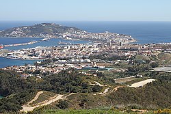
သူးတ
သူးတ
| |||
|---|---|---|---|
ဝဵင်းၽွင်းငမ်းႁင်းၶေႃ | |||
 | |||
| |||
 Location of Ceuta within Spain | |||
| Coordinates: 35°53′18″N 5°18′56″W / 35.88833°N 5.31556°Wၵူဝ်ႇဢေႃးတိၼဵတ်ႉ: 35°53′18″N 5°18′56″W / 35.88833°N 5.31556°W | |||
| မိူင်း | |||
| ဝဵင်းၽွင်းငမ်းႁင်းၶေႃ | သူးတ | ||
| First settled | 1st millennium BC | ||
| End of Muslim rule | 14 August 1415 | ||
| Ceded to Spain | 1 January 1668 | ||
| Autonomy status | 14 March 1995 | ||
| Founded by | Carthaginians | ||
| Government | |||
| • Type | Autonomous city | ||
| • Body | Council of Government | ||
| • Mayor-President | Juan Jesús Vivas (PP) | ||
| Area | |||
• Total | 18.5 လွၵ်းၵီႇလူဝ်ႇမီႇတႃႇ (7.1 လွၵ်းလၵ်း) | ||
| • Land | 18.5 လွၵ်းၵီႇလူဝ်ႇမီႇတႃႇ (7.1 လွၵ်းလၵ်း) | ||
| Elevation | 10 မီႇတႃႇ (30 ထတ်း) | ||
| Highest elevation | 349 မီႇတႃႇ (1,145 ထတ်း) | ||
| Population (2018)[1] | |||
• Total | 85,144 | ||
| • Density | 4,600/km2 (12,000/sq mi) | ||
| Demonyms | Ceutan ceutí (es) | ||
| Time zone | UTC+1 (CET) | ||
| • Summer (DST) | UTC+2 (CEST) | ||
| ISO 3166 code | ES-CE | ||
| Postal code | 51001–51005 | ||
| Official language | Spanish | ||
| Parliament | Cortes Generales | ||
| Congress | 1 deputy (out of 350) | ||
| Senate | 2 senators (out of 264) | ||
| Website | Ceuta.es | ||

